Technical Reports: Joint research activities*
|
SERA work package |
WP 23 / JRA 1 |
|
Authors |
K. Leptokaropoulos, M. Sobiesiak, S. Lasocki, N. Poiata, K. Palgunadi, P. Bernard, C. Satriano |
|
Keywords |
Statistical toolboxes, induced seismicity in mines, enhanced seismic data set, Rudna and Garpenberg mines |
Induced seismicity

Figures: (Left frame) Example from Toolbox 1 (Magnitude Distributions). The graph shows the application of the Anderson-Darling test for magnitude distribution as applied to the data set from Song Tranh 2 water reservoir, Vietnam. (Right frame) Blue dots mark the spatial distribution of located events during half an hour after a large mine collapse on 15th of Sept., 2018 in Rudna mine. Stars give the locations of the main (red) and the first aftershock (yellow). The features lined out by the seismicity are the major production level (horizontal alignment), and probably shafts (vertical alignments).
Main Results
IG-PAS contributed to JRA1 with the development and implementation of two Matlab software toolboxes for studying earthquake clustering and magnitude complexity, which are applicable to both natural and anthropogenic seismicity cases. Each software comprises two separate applications, developed in three individual versions: One interactive standalone version (V1), one function-like version (V2) and one online version (V3) integrated within the IS-EPOS platform. All programs together with auxiliary scripts, complete user guide documentation and sample data are freely available via GitHub. In addition to the aforementioned software, an application of the methodology connected with Toolbox 2 was performed and submitted for publication.
A second topic IG-PAS contributes to JRA1 is the investigation of induced seismicity through mining activities in the deep Rudna copper mine, Poland. The mine is known for the occurrence of intermediate magnitude events of up to M4, causing considerable damages and even fatalities. By applying the automated detection and location algorithm of the BackTrackBB software (Poiata et al., 2016), in collaboration with CNRS, we could demonstrate that we are able to monitor induced seismicity and signals from mining activities with a surface network in a sufficient resolution to line out the major mine features. Several enhanced data sets could be achieved with a much larger amount of located events than in previous routine seismicity catalogues.
CNRS developed and applied a full-waveform-based automatic method for improved detection and location of microseismic events that makes use of continuous seismic records from an in-mine seismic network, and can be adjusted to a near-real-time monitoring scheme. The method consists of two steps:
- event extraction and amplitude ratio-based preliminary location
- event relocation by using a coherency-based back projection approach
The event extraction, based on multi-band signal characterization implemented in the first step, allows us to overcome the challenge of high sampling rate data (8 kHz), reducing the volume of transferred data and providing an energy-based signal classification scheme. This approach allows us to remove a significant number of machinery noise sources. The technique is developed and tested with the Institut National de l'Environnement Industriel et des Risques (INERIS) on the case study of the Garpenberg mine (Sweden) monitored by a local seismic network and maintained by INERIS. We demonstrated the improvement in event detection capacity by a factor of 50, compared with the standard triggered-based monitoring schemes. This increased number of detected microseismic events permits us to investigate the migration pattern of induced microseismicity that is generated in response to production blast.
List of Publications
- Palgunadi, K.H., N. Poiata, J. Kinscher, P. Bernard, F. De Santis and I. Contrucci. (2019), "Methodology for full waveform near real-time automatic detection and localization of microseismic events using high (8 kHz) sampling rate records in mines; application to the Garpenberg Mine (Sweden)", Seismol. Res. Lett. 91 (1): 399-414.
- Leptokaropoulos, K. (2020), "Magnitude distribution complexity and variation at The Geysers geothermal field", submitted to Geophys. J. Int., under revision.
Access to Data and Services
- Access to Statistical Toolboxes (codes, sample data, documentation) can be found at: https://git.plgrid.pl/ projects/EA/repos/sera-applications/browse
- The BackTrackBB full-waveform detection and location software used in the analysis is available from Git-Hub (http://backtrackbb.github.io) on open-source basis
|
SERA work package |
WP 24 / JRA 2 |
|
Authors |
Bindi, R. Zaccarelli, A. Strollo, G. Di Giacomo, J. Quinteros and F. Cotton |
|
Keywords |
Earthquake ground motion, seismic source observations, harmonized magnitude scale, regional attenuation, engineering seismology |
Toward harmonized local magnitude attenuation function for Europe using massive events datasets

Figure 1. Harmonized local magnitude scale for Europe. Top left: source to station ray paths considered to derive the non-parametric attenuation models regionalized into six macro-domains indicated with different colours; points indicate the location of the analysed earthquakes (about 12 thousand). Bottom left: example of parametric analysis performed over 5 network, four operating on Germany (network codes TH, GR, SX, BW) and the fifth in Switzerland (network code CH). Right: comparison among the parametric magnitude functions obtained for the five considered networks (coloured lines) and the non-parametric model derived for central Europe (region 1, shown with red paths in the left panels). Figure modified from Bindi et al. (2019).
Main Results
In the last two decades, the development of international infrastructures for data sharing (e.g. EIDA- European Integrated Data Archive; IRIS- Incorporated Research Institutions for Seismology) and the standardization of the formats for data archiving and dissemination (FDSN- International Federation of Digital Seismograph Networks) allowed the seismological community to overcome the difficulties in merging data from different networks and countries. In this study, we took advantage of the EIDA to develop the first harmonized local magnitude scale for central and southern Europe, and to quantify regional differences in the attenuation models (Bindi et al., 2019). Using an open-source tool developed to carry out this task and similar (Zaccarelli et al., 2019), we created a local data base including about half million selected waveforms with related metadata, corresponding to about 12’000 earthquakes occurred in Europe in the magnitude range from 2 to 7. The calibration of regional non-parametric attenuation functions highlighted significant regional differences in the rate of attenuation among the six considered macro-areas. Within the macro-areas, crustal heterogeneity affects the propagation of seismic waves differently, for example later arrivals impact the ground motion at different distance ranges.
In order to compare the magnitudes provided by different seismological observatories in Europe, a parametric approach has also been developed considering adjustments to the attenuation coefficients at the level of each single network. Following this approach, more than 70 different parametric magnitude scales were derived following, for the first time in Europe, a harmonized approach without political or infrastructural borders. The possibility to refer to a harmonized magnitude scale makes easier the operation of comparing and merging catalogues provided by different networks. Furthermore, it allows to jointly analyse amplitudes recorded at stations belonging to different networks operating in adjacent regions. The newly derived magnitude scale can be used as reference magnitude scale for applications where local to moment magnitude scale conversions are required for seismic hazard assessment purposes. For this reason, future work will investigate the possibility to compare the magnitudes obtained from the homogenized calibration functions with those reported in the ISC bulletin, as collected from several European networks.
List of Publications
- Bindi, D., Zaccarelli, R., Strollo, A., Di Giacomo, G. (2019). Harmonized local magnitude attenuation function for Europe using the European Integrated Data Archive (EIDA), Geophysical Journal International, 218, 1, 519-533. https://doi.org/10.1093/gji/ggz178
- Zaccarelli, R., Bindi, D., Strollo, A., Quinteros, J. and Cotton, F., (2019). Stream2segment: an open source tool for downloading, processing and visualizing massive event-based seismic waveform datasets, Seimol. Res. Letters 90 (5): 2028–2038, doi: 10.1785/0220180314
Access to Data and Services
- The software stream2segment is free available at: https://geofon.gfz-potsdam.de/software/stream2segment/
- The attenuation coefficients of the calibrated magnitude models are available at: https://gfzpublic.gfz-potsdam.de/pubman/item/item_4224891
- Only open data have been used to derive the models, available from EIDA https://www.orfeus-eu.org/data/eida/
|
SERA work package |
WP 25 / JRA 3 |
|
Author |
L. Danciu |
|
Keywords |
Earthquake hazard, seismic hazard assessment, European Seismic Hazard Model (ESHM20), seismogenic sources, ground motion characteristic models, seismic hazard |
Update of the 2020 European Seismic Hazard Model (ESHM20)
Main Results
The 2020 European Seismic Hazard Model (ESHM20) provides an updated version of the earthquake hazard assessment of the Euro-Mediterranean region. The model has been developed on the basis of the most recent datasets, which means earthquake catalogues, active faults and ground shaking recordings. In addition, tectonic and geological information as well as models (seismogenic sources, ground shaking) were also used. A full probablistic framework was adopted to develop and implement the seismic hazard model with focus on cross-border harmonization. Furthermore, the ESHM20 development phase involved several regional workshops where the national experts have been consulted and their feedback was acknowledged and considered.
The newly developed seismogenic source model encompasses fully harmonized as well as cross-borders seismogenic sources and is following the recent national earthquake hazard models. The inherent uncertainties in characterizing the earthquake rupture forecast are handled by a complex logic tree, which consists of two main models (branches): an area source-based model and a hybrid fault-smoothed seismicity model. The ground motion characteristic model is built upon the most complete ground shaking recordings in Europe. It aims at capturing the effects of source and attenuation path of the expected ground shaking at a site. The regional variability of ground shaking is assessed based on the most updated dataset of ground motion recordings across Europe. A novel statistical approach was developed to assess the regional ground motion characteristics and the overall uncertainties are handled in a backbone logic tree. Finally, a complex input model, handling the intrinsic epistemic uncertainties of both seismogenic sources and ground shaking models, was used for assessing the earthquake ground shaking across the entire Euro-Mediterranean region. The open-source hazard library of OpenQuake was used, which facilitates the transparency of the models and allows to fully reproduce the results.
A full set of hazard results such as hazard curves and maps as well as uniform hazard spectra is provided for the entire region covered by ESHM20. Note that the results calculated through the ESHM20 represent ground shaking hazard forecasts on EC8 rock site class B with a VS30 of 800 m/s. Two additional hazard maps describing the spatial distribution of the engineering spectral factors (i.e. Salpha and Sbeta) are also provided with a uniform probability of exceedance of 10 % in fifty years. These two factors will form the basis of the future update of the European Seismic Design Code (CEN-EC8) aiming to reduce the potential of human casualties and economic losses from severe ground shakings in a long-term view.
Access to Data and Services
All datasets, key components and results are open for access and re-use at the web-platform of European Facilities of Earthquake Hazard and Risk (www.efehr.org).
List of Publications
A special issue describing the efforts undertaken to develop the 2020 European Seismic Hazard Model is planned and its content will be communicated in the next months.
|
SERA work package |
WP 26 / JRA 4 |
|
Authors |
H. Crowley, V. Despotaki, D. Rodrigues, V. Silva, D. Toma-Danila, E. Riga, A. Karatzetzou, S. Fotopoulou, L. Sousa, S. Ozcebe, P. Gamba, & Contributors) |
|
Keywords |
Seismic risk, European exposure, buildings, population |
European Exposure data for seismic risk modelling

Figure 1. Interactive European Exposure Model
Main Results
One of the main results of JRA4 that has been achieved relates to the development of the European Exposure Model, which provides the geographical distribution of population, replacement cost of buildings, and total number of buildings (residential, commercial, industrial), and their distribution between different construction materials. The data presented in the figure above is within administrative level 0 (country) boundaries, but it has also been developed at a higher resolution that will be released at the end of the SERA project. This version of the model shown above has been integrated within the Global Earthquake Model (GEM) Global Exposure Map (v2018.1) that was used in the Global Seismic Risk Map (v2018.1). The datasets employed to develop this exposure model were publicly provided through national institutions and local experts. The European Exposure Model is intended to be a dynamic product, such that it may be updated when new datasets and models become available.
This European Exposure Model has been released through the new European Seismic Risk Service which is part of the European Facilities for Earthquake Hazard and Risk (EFEHR), a non-profit network of organisations and community resources aimed at advancing earthquake hazard and risk assessment in the European-Mediterranean area. The new risk service of EFEHR has been set up with the main objective of providing interactive access to the seismic risk products that will be developed by the end of the SERA project, which in addition to exposure data and models will include the following:
- European capacity curves, fragility, consequence and vulnerability models.
- European seismic risk results in terms of average annual loss (AAL), probable maximum loss (PML), and risk maps in terms of economic loss and fatalities for specific return periods and indicators of the Sendai Framework for Disaster Risk Reduction.
- Methods and data to test and evaluate the components of seismic risk models.
- Documentation on all of the datasets and models.
- Scientific support on the development of the models and seismic risk computations.
List of Publications
- Crowley, H., Rodrigues, D., Silva, V., Despotaki, V., Marins, L., Romão, X., Castro, J.M., Pereira, N., Pomonis, A., Lemoine, A., Roullé, A., Tourlière, B., Weatherill, G., Pitilakis, K., Danciu, L., Correira, A.A., Akkar, S., Hancilar, U., Covi, P. (2019). “The European Seismic Risk model 2020 (ESRM20),” Proceedings of 2nd International Conference on Natural Hazards and Infrastructure, ICONHIC 2019
- Crowley, H., Despotaki, V., Rodrigues, D., Silva, V., Toma-Danila, D., Riga, E., Karatzetsou, A., Sousa, L., Ozcebe, S., Zugic, Z. & Gamba, P. (2019). “Exposure model for European Seismic Risk Assessment,” Earthquake Spectra, accepted for publication.
Access to Data and Services
You can access the European exposure data through interactive viewers (https://maps.eu-risk.eucentre.it/) or through web services. For example, you can bring the exposure layers shown in the figure above into QGIS by first copying the WMS or WMTS links you find on this page: https://eu-risk.eucentre.it/web-services/. Then, in the Browser of QGIS you should right click the WMS/WMTS option and choose ‘New Connection’ and copy the URL in the box that pops up (giving it an appropriate name).
|
SERA work package |
WP 27 / JRA 5 |
|
Authors |
P. Covi, N. Tondini, M. Korzen, M. Lamperti Tornaghi, G. Tsionis, P. Pegon, J. Molina, M. Peroni, G. Abbiati, L. Danciu, M. Antonelli, B. Gilardi |
|
Keywords |
Fire following earthquake, earthquake engineering, fire engineering, concentrically braced steel frames, large-scale tests, pseudo-dynamic testing, sub-structuring |
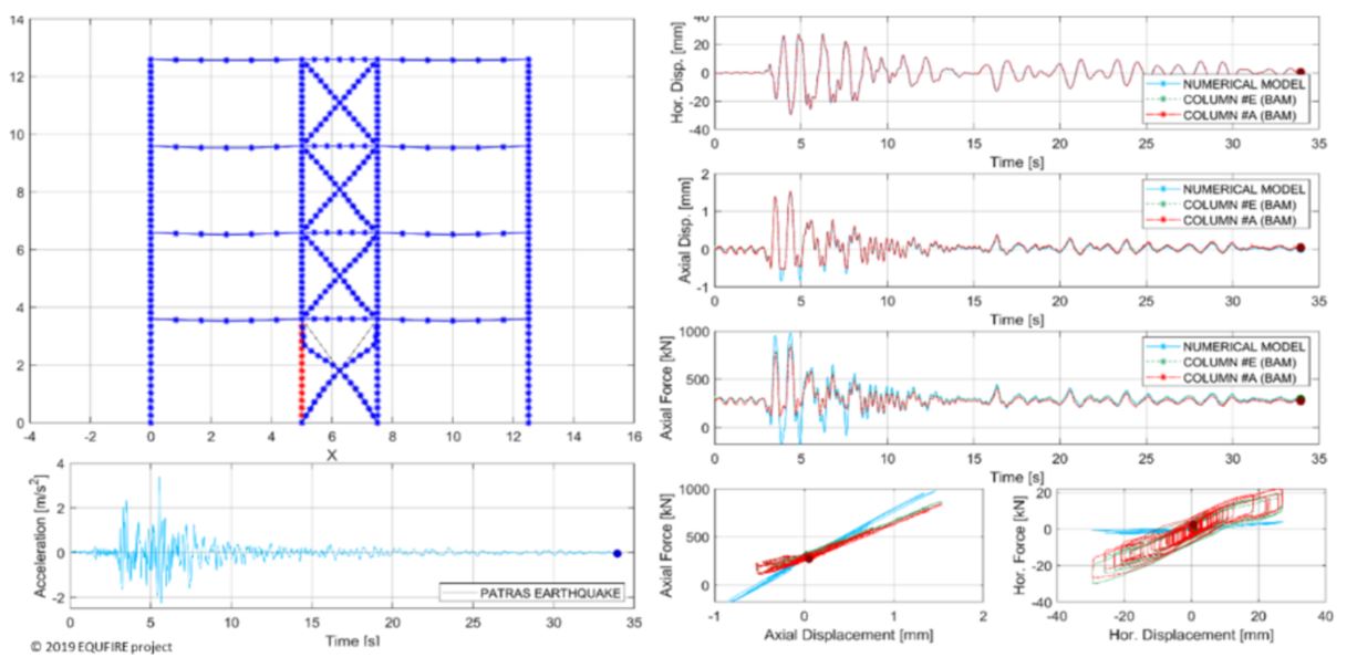
Advancements in experimental and numerical study of braced steel frames subjected to fire after earthquake

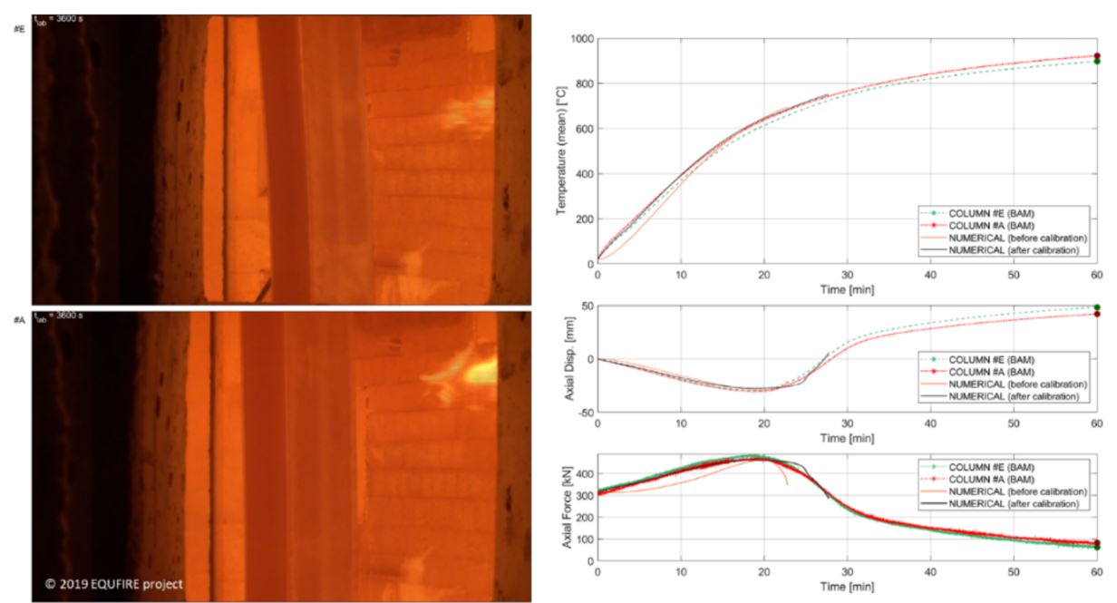
Figure 1a
Test #0 and #1. Comparison between results obtained after the seismic hybrid test on column without fire protection and the numerical model before the calibration (Positive axial force is tension and negative axial force is compression).

Main Results
The EQUFIRE project aims to study the post-earthquake fire performance of steel frame structures and is part of the Transnational Access activities of the SERA project at the ELSA Reaction Wall of the Joint Research Centre. A four-storey three-bay steel frame with concentric bracing in the central bay illustrated in Fig. 1a was selected as a case study.
The internal column at the ground floor of the braced frame was substructured at the BAM (Federal Institute for Materials Research and Testing / Bundesanstalt für Materialforschung und -prüfung) facilities, while the rest of the structure was numerically simulated. Five fire following an earthquake (FFE) tests were conducted at BAM in October and November 2019:
- Test #0 Column E: “without fire protection system”
- Test #1 Column A: “without fire protection system”
- Test #2 Column B: “fire protection system, PROMATECT-H, seismic installation”
- Test #3 Column C: “fire protection system, PROMATECT-H, normal installation”
- Test #4 Column D: “seismic-resistant sprayed vermiculite-type fire protection”
The mechanical loading of the columns was achieved by six servo-hydraulic control loops representing two rotation degrees of freedom perpendicular to each other for bending at the upper and lower bearing as well as one channel for bottom axial and one for top horizontal loading.
The comparison between the numerical model and the hybrid test demonstrated good agreement between the partitioned solutions under seismic and fire conditions. There is a little difference in negative vertical displacement, due to the fact that tension (negative) axial force was not allowed during the test as illustrated in Fig 1a. That’s because the axial actuator of the furnace is not designed to give tension axial forces to the specimen but only compression axial forces (By way of explanation, the axial actuator of the facility can “push” the specimen but cannot “pull” it).
The test data were used to calibrate the numerical model and they will also serve for the next tests at the ELSA Reaction Wall (JRC). The comparison between experimental and numerical data before and after calibration is presented in Fig. 1b. The calibration process consisted of modelling the base joint based on its actual initial stiffness and of applying the recorded steel temperature evolution in the columns.
Meanwhile, other three FFE tests were carried out with the same specimen proprieties but with different type of fire protections.
The tests with the protected column showed some cracks on the fire protection due to the combination of seismic and fire conditions. However, those cracks are not large enough to compromise fire resistance. In this respect, more damage to the bracing system is expected during the tests at ELSA -JRC. The experimental activities at the ELSA Reaction Wall comprise pseudo-dynamic tests on a full-scale specimen of the first storey of the building, while the upper three storeys will be numerically simulated. The tests will be held at the beginning of 2020.
List of Publications
- Abbiati, G., Covi, P., Tondini, N., Bursi, O.S. & Stojadinovic, B. "A Finite Element Tearing and Interconnecting-Based Algorithm for Hybrid Fire Testing" - COUPLED 2019: VIII International Conference on Coupled Problems in Science and Engineering, Sitges (Barcelona), 3-5 June 2019
- Abbiati G., Covi, P., Tondini, N., Bursi, O.S & Stojadinović, B. “Real-Time Hybrid Fire Simulation Based on Dynamic Relaxation", Journal of Engineering Mechanics, 2019 (Paper under review)
|
SERA work package |
WP 28 / JRA 6 |
|
Authors |
A. Zollo, M. Böse, R. Bossu, C. Cauzzi, T. Dahm, B. DeLouis, A. Michelini |
|
Keywords |
Real-Time Earthquake shaking, Rupture kinematics, shake-maps, qualitative impact assessment |
Real-time earthquake shaking

Figure 1: Schematic description WP 28 objectives. (top) At the occurrence of an event, moving on the timeline in the P-waves time window fast estimates of the hypocenter, magnitude and fault geometry are computed. During the recording of the S-wave phase, the closest real PGx estimates become available. The S-waves recording, along with the previous estimates, are hence used to compute refined source models with complementary approaches. Finally, these models are to compute refined synthetic seismograms and the final Shake Maps. (bottom) The definition of a refined source model is expected to reduce the uncertainty on the PGx estimates a few minutes after the end of the event.
Main Results
In the past decade, real-time seismology has moved from providing post-event information within minutes from earthquake occurrence, to issuing event information during or shortly after the rupture.
We compare the performance of four independent algorithms in the calculation of finite-fault models, through their application to the 2016-2017 Central Italy earthquake sequence and a dataset of 19 large global earthquakes. We show that two algorithms (developed at ETH Zurich (ETHZ) and Università degli Studi di Napoli Federico II (UNINA) using near-source accelerometric stations) can provide robust finite-fault models within 10 to 15 seconds from the event occurrence, for earthquake early warning applications. Other two algorithms (developed at GFZ Potsdam and Instituto Nazionale di Geofisica e Vulcanologia (INGV), using regional/global broadband waveforms) can provide more detailed finite-fault models within 10-20 minutes from event origin, for rapid response applications.
The testing attenuation models from earthquakes recorded in Central Italy confirmed the strong frequency dependence of ground motion residuals and variability, and the complementarity of the magnitude scales considered in the Ground Motion Prediction Equation (GMPE). Since the source parameter stress drop is observed to improve the ground shaking prediction, a procedure is proposed by GFZ for the rapid assessment of the shaking potential which uses the seismic moment and the radiated energy measured over the seismograms. The development of numerical Green function databases was integrated into a python based simulation toolbox, in order to simulate ground motion parameter for different earthquake scenarios rapidly. The feasibility of a European ShakeMap system has been further tested and realized by prototype implementations at ETHZ, INGV and the National Observatory of Athens (NOA).
The Swiss Seismological Service (SED) at ETHZ finalised the upgrade of the Earthquake Early Warning Display (EEWD) to integrate source information from Real-time Finite Fault Rupture Detector (FinDer) and to include ground shaking estimates consistent with the FinDer rapid simplified finite fault representation as a line segment.
We explored two different strategies (SLIPNEAR CNRS and Back-Projection UNINA) for the rapid estimation of the earthquake source models. The final goal is to use these refined, kinematic source models for the computation of synthetic seismograms and shake maps, with the aim of reducing the uncertainties on the ground shaking prediction. The SLIPNEAR and Back-Projection are shown to provide complementary images of the source. These projections allow constraining the main patches of low-frequency slip and the high-frequency asperities (such as the arrest phase) respectively.
To compute evolutionary updated ground shaking prediction, the rapid estimates of the magnitude, location and fault geometry allow updating the point-source shaking prediction by applying Joyner & Boore distance-based GMPEs. Meanwhile, this early geometrical description and, at a later stage, the source inversions is used by UNINA to compute shaking prediction through sets of forward source modelling. The final aim is to integrate over different time scales (from EW to Rapid Response) real data, attenuation law and simulated PGx by using a ShakeMap-based interpolation scheme.
The final main outcome of this WP is the provision of rapid estimates of exposure and qualitative assessments of impact deriving for an earthquake and its strong ground shaking. The partners have developed independently procedures for rapid assessments using very diverse approaches:
- to detect earthquake damage from the lack of crowdsourced data, make very fast location and magnitude estimate of felt earthquakes (EMSC)
- Rapid calculation of exposure qualitative assessment of impact using the tools provided by SesDARO (the near real-time system for estimating the seismic damage in Romania, NIEP) and the ARISTOTLE project (INGV)
Within the framework of SERA, WP 28 has developed various services to ease the access to public databases of main infrastructures potentially affected by relevant ground shaking. We are expecting that those services will provide more complete descriptions of exposure and impact assessment.
Both INGV and the SED have started the migration their institutional ShakeMap systems to the new USGS version 4.0 that features the improved interpolation method described by Worden et al. (2018) and makes use of the ground motion models as implemented in OpenQuake (Pagani et al., 2014). The transition of the European prototype system to v4.0 is planned along with further community building activities.
List of Publications
- Böse, M., Smith, D.E., Felizardo, C., Meier, M-A., Heaton, T.H., Clinton J.F. (2018). FinDer v.2: Improved real-time ground-motion predictions for M2–M9 with seismic finite-source characterization, Geophysical Journal International, 10.1093/gji/ggx430.
- Bossu, R. & Steed, R. & Roussel, F. & Landès, M., Fuenzalida, A., Matrullo, E., Dupont, A., Roch, J. & Fallou, L. (2018). App Earthquake Detection and Automatic Mapping of Felt Area 1. Seismological Research Letters, 90. 10.1785/0220180185.
- Colombelli, S., Carotenuto, F., Elia, L., & Zollo, A. Design and implementation of a mobile device app for network-based earthquake early warning systems (EEWSs): application to the PRESTo EEWS in southern Italy. Nat. Hazards Earth Syst. Sci., 20, 921–931, 2020, https://doi.org/10.5194/nhess-20-921-2020.
- Festa, G., Picozzi, M., Caruso, A., Colombelli, S., Cattaneo, M., Chiaraluce, L., Elia, L., Martino, C., Marzorati, Supino, M. & Zollo, A. (2018). Performance of Earthquake Early Warning Systems during the 2016-2017 Mw 5-6.5 Central Italy Sequence Seismological Research Letters, 10.1785/0220170150.
- Nazeri, S., Colombelli, S. & Zollo, A. (2019). Fast and accurate determination of earthquake moment, rupture length and stress release for the 2016-2017 Central Italy seismic sequence, Geophysical Journal International, https://doi.org/10.1093/gji/ggz097.
- Picozzi, M., Bindi, D., Spallarossa, D., Di Giacomo, D. & Zollo, A. (2018). A rapid response magnitude scale for timely assessment of the high frequency seismic radiation, Scienitfic Reports, 10.1038/s41598-018-26938-9.
- Robert, J., Steed, R., Fuenzalida, A., Bossu, R., Bondár, I., Heinloo, A., Dupont, A., Saul, J. & Strollo, A. (2019). Crowdsourcing triggers rapid, reliable earthquake locations, Science Advances, 10.1126/sciadv.aau9824.
- Scala, A., Festa, G.& Del Gaudio, S. (2018). Relation Between Near-Fault Ground Motion Impulsive Signals and Source Parameters, Journal of Geophysical Research - Solid Earth 10.1029/2018JB015635.
- Spallarossa, D., Kotha Sreeram, R., Picozzi, M., Barani, S. & Bindi, D. (2018). On-site Earthquake Early Warning: a partially non-ergodic perspective from the site effects point of view, Geophysical Journal International, 10.1093/gji/ggy470.
- Subach G. (2018). Study of the uncertainties associated to the Building Damage Prediction equation, Master Thesis, University Grenoble Alpes.
- Scala, A., Festa, G., Vilotte, J-P., Lorito, S. & Romano, F. (2019). Wave Interaction of Reverse‐Fault Rupture With Free Surface: Numerical Analysis of the Dynamic Effects and Fault Opening Induced by Symmetry Breaking, Journal of Geophysical Research: Solid Earth, 10.1029/2018JB016512
- Tarantino, S., Colombelli, S., Emolo, A. & Zollo, A. (2019). Quick determination of the earthquake focal mechanism from the azimuthal variation of the initial P-wave amplitude, Seismological Research Letters, 10.1785/0220180290.